
Well, it finally happened. I got doored today down in Fisherman's Wharf while riding home. I was riding along Beach St. towards the bridge. As I got to Hyde, there was a line of cars waiting at the light, one of which was signaling a left turn. This street has one lane in each direction, so I started riding along the right side of the stopped cars in the (fairly decent sized) gap between the passenger side of the cars and the edge of the roadway. There is no sidewalk here, just an iron railing which guards a 6 foot drop down to a sunken walkway behind a commercial building. So basically there is no place for a car to pull over, no place for a pedestrian to walk here, nor is there any spot for a passenger to exit a stopped car.
Of course this did not stop the guy who decided at the very moment I was riding past, to throw open the back door of the taxicab (4 back from the stoplight, in the middle of the lane) and T-bone me directly on the left arm, leg and handlebar. I bounced off, careened into the iron railing and snapped out of my pedals as I fell to the ground. After some hyperventilating and adreneline-influenced shouting and finger pointing, I calmed down to make sure I wasn't injured (and more importantly, that my bike wasn't injured). We weren't.
So the taxi rode off. The passenger walked off, and I nursed my bruises all the way home. Incidentally, I saw the guy cross the street and walk into the Buena Vista, presumably for a St. Patrick's Day whiskey. Was probably drunk when he flung the door open on me.
I played over in my head whose fault this accident was. In some ways we were probably all a little bit negligent here -- the passenger for not looking to make sure the roadway was clear before opening the door, the driver for letting the guy out in the middle of the goddamn street, and me for not demonstrating the proper respect anytime you ride your bike in proximity to a taxi cab -- especially in a touristy part of town. I think I had the legal right to ride alongside the cars (California law seems to allow multiple "vehicles" per lane, and requires bikes to ride on the right), but even if that's true there's a big difference between being "right" legally and being "wrong" based on the damage a car door can do to you.
Be careful out there. I got lucky this time.
Monday, March 17, 2008
Saturday, November 3, 2007
Tiburon to Half Moon Bay
It is fall and Halloween time. That can mean only one thing -- the Pumpkin Patch kid trap at Lemos Farm in Half Moon Bay. This place has monster locally grown pumpkins, pony rides, jumpy houses, a haunted train ride, unhealthy snacks, etc. etc. In short, everything you could want when you have two rambunctious kids. Always looking for an excuse to ride the bike (especially on a new route), I meekly suggested to Dana that I could meet her and kids down there. It is only about 45 miles from our house in Tiburon to Lemos Farm, and all of it along the mighty Pacific. Sounded like a good ride. It was. Apart from a scary ride along Devil's Slide -- where I thought the winds were going to hurtle me into the abyss -- it was a good, fast ride. I even got there before the family.
 The ride gets interesting at the end of Great Highway. After winding over to Skyline Blvd (Hwy 35), you are best getting off where it turns into a freeway (at Westmoor) and doing the VERY steep climb on the parallel street called Skyline Dr. This then drops equally steeply down into Pacifica. You pick up Palmetto and ride all the way to the end and pick your way across, parallel to the freeway along Francisco, Bradford and Morris Point. From here you are on the highway, which ultimately narrows as it begins its climb up to Devil's Slide. This part is not that fun, as the climb is steep and the road somewhat scary. The upside is that it is only about 2 miles until you are back on a big shoulder.

View down from the slide. Holy crap! Don't slip. It was very windy around this corner, so I just took the whole lane and prayed that the cars behind me had patient drivers.
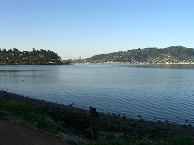
 Sunrise over SF Bay from the Sausalito waterfront

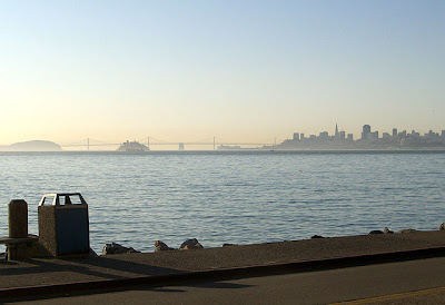
Racing a container ship to the Golden Gate (I won)

The bridge from Vista Point

Looking out over Seacliff from Lincoln Blvd in the Presidio. Hard to believe that everything you see here is completely within the 7x7 city limits of San Francisco. What a city.

The Cliff House
 Ocean Beach in San Francisco. Marin Headlands in the distance.
 Boardwalk at Ocean Beach along the Great Highway
 The ride gets interesting at the end of Great Highway. After winding over to Skyline Blvd (Hwy 35), you are best getting off where it turns into a freeway (at Westmoor) and doing the VERY steep climb on the parallel street called Skyline Dr. This then drops equally steeply down into Pacifica. You pick up Palmetto and ride all the way to the end and pick your way across, parallel to the freeway along Francisco, Bradford and Morris Point. From here you are on the highway, which ultimately narrows as it begins its climb up to Devil's Slide. This part is not that fun, as the climb is steep and the road somewhat scary. The upside is that it is only about 2 miles until you are back on a big shoulder.
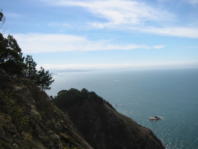
Looking down at Devil's Slide from the top of the climb (where the new bypass tunnel is being built). You can just see a sliver of the roadway below. That is the scary part.

View down from the slide. Holy crap! Don't slip. It was very windy around this corner, so I just took the whole lane and prayed that the cars behind me had patient drivers.

Tuesday, July 3, 2007
From the Beach to Work
We're at the beach for the July 4 week, but had to go to work today. So today's ride was even more spectacular than the everyday "mundane" commute.
The Ride:
http://www.mapmyride.com/ride/united-states/ca/san-francisco/553106804
Some photos (not taken by me, but show some of the highlights of the route).
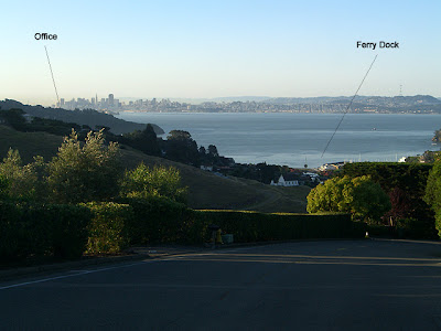
Stinson Beach. The pad we are staying in is beachside right in the clump of trees near the point. The ride goes along the beach,then up the big cliffs towards SF, about 28 miles to the office.

6 miles of righteous coastline later: Muir Beach and Overlook.

A long twisty descent into Mill Valley where I picked up the"regular" commute into Sausalito and over the bridge. A gorgeous day in Marin, but the fog was firing (pretty gray in SF today...)
I live in the greatest place on earth!!!
The Ride:
http://www.mapmyride.com/ride/united-states/ca/san-francisco/553106804
Some photos (not taken by me, but show some of the highlights of the route).
Stinson Beach. The pad we are staying in is beachside right in the clump of trees near the point. The ride goes along the beach,then up the big cliffs towards SF, about 28 miles to the office.
6 miles of righteous coastline later: Muir Beach and Overlook.
A long twisty descent into Mill Valley where I picked up the"regular" commute into Sausalito and over the bridge. A gorgeous day in Marin, but the fog was firing (pretty gray in SF today...)
I live in the greatest place on earth!!!
Wednesday, May 9, 2007
The Bike-to-Work Commute
May is Bike-to-Work month, so I figured I would post my commute. Depending on weather and season, I generally do this a few times a week, and sometimes I also add in a return trip on the ferry if time is tight or I'm just not feeling up to the ride.
Route Map: http://www.mapmyride.com/view_route?r=450c177e4a8a7d1bc7bdbf10e76ee0fc
 Coming down the hill from the house. Objective in sight, 18.9 miles away. The ride goes way back out of picture right, over the GG bridge and into the city.
 Early morning cruise along the bike path. The bridge is visible over Richardson Bay. A quick ride into Mill Valley, where the local wildlife is out in force on the bike path, if you know what I mean. The scenery is pretty good on this ride.
 Gets even better as you get into Sausalito on the waterfront.
 A quick but stout climb up Fort Baker makes the kid break a sweat.
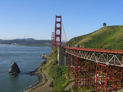
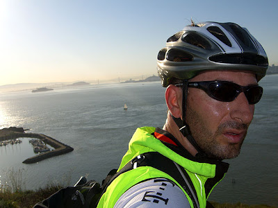
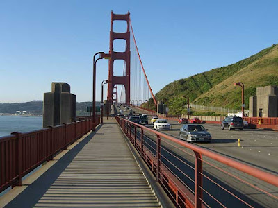 Some orange bridge I gotta cross
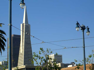 Then into the city, where the buildings look funny.
 Past the cruise ships and tourists.
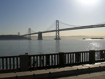 Along the Embarcadero, past the SF Ferry building (where I can catch the boat home if I'm bailing out on the return trip). Nice view of the Bay Bridge along the way.
 And then I arrive at the office, almost exactly an hour after I start pedaling.

In the afternoon, I reverse the ride on the way home. The ride back to the the bridge is generally very windy, with the afternoon gales blowing into the Golden Gate. The famous San Francisco fog is never too far away and always seems to come back in after being away for only a couple of hot days. Sure enough on this day, by the time I got back up to the house, she was coming back in to say hello.
Route Map: http://www.mapmyride.com/view_route?r=450c177e4a8a7d1bc7bdbf10e76ee0fc
 Coming down the hill from the house. Objective in sight, 18.9 miles away. The ride goes way back out of picture right, over the GG bridge and into the city.
 Early morning cruise along the bike path. The bridge is visible over Richardson Bay. A quick ride into Mill Valley, where the local wildlife is out in force on the bike path, if you know what I mean. The scenery is pretty good on this ride.
 Gets even better as you get into Sausalito on the waterfront.
  A quick but stout climb up Fort Baker makes the kid break a sweat.
 Some orange bridge I gotta cross
 Then into the city, where the buildings look funny.
 Past the cruise ships and tourists.
 Along the Embarcadero, past the SF Ferry building (where I can catch the boat home if I'm bailing out on the return trip). Nice view of the Bay Bridge along the way.And then I arrive at the office, almost exactly an hour after I start pedaling.
In the afternoon, I reverse the ride on the way home. The ride back to the the bridge is generally very windy, with the afternoon gales blowing into the Golden Gate. The famous San Francisco fog is never too far away and always seems to come back in after being away for only a couple of hot days. Sure enough on this day, by the time I got back up to the house, she was coming back in to say hello.
Sunday, July 16, 2006
The Alpine Bike-Ski-Climb Triathlon
Mount Conness on the east side of Yosemite is a great natural playground. My friends and I have always looked at it as the perfect place to combine great skiing and climbing into one trip. Conness has some world-class alpine routes on its north and west ridges, as well as its massive southwest face. It is also blessed with great late season skiing in the chutes that drop off the northeast side of the mountain and also on the Conness Glacier itself. The idea would be to climb up to the summit plateau, drop skis there, continue down to the foot of the west ridge, climb to summit, then ski back down. Easy right?
Well, not really. 2006 proved to be a massive snow year in the Sierra and the road from Tioga Pass up to Saddlebag Lake was still gated closed last weekend. This is no problem for a cyclist -- you simply pile 75 pounds of climbing, skiing and overnight gear onto your back, and then climb onto your poor bike and ride to the mountain. My friend Abe and I did just that made it a mountain trifecta -- an alpine triathlon.
We also stretched it into a two day trip so we could savor the skiing a bit more and not risk getting caught out on the open should a storm hit. In the end, we just escaped one of the most intense electrical and hailstorms I've ever been in, so our timing was excellent. The skiing was sweet and the climbing even better. The cycling was average at best, but riding bikes was of course just the gravy on the trip. In fact, right as we dismounted our bikes at the trailhead, a ranger pulled up in his pickup truck and told us that he had just opened the road up. D'oh! Oh well, the story wouldn't have been quite as good without the insanely stupid bike schlepp.
 Abe navigates the crux of the east ridge approach
 Yours truly near the top with the entire east ridge approach route behind me.
 Success! Reaching the summit plateau gives a fantastic view over the granite monuments of Tuolumne Meadows
 Abe drops into the Y-Couloir.
 At the summit (third time's a charm!). As you can see in this photo, the skies are still clear. Within minutes, clouds began building in the west so we hightailed it back to camp.
 We packed all our gear up as quickly as we could and started skiing down. It hit us quickly. Abe skis down as the rain starts.
Well, not really. 2006 proved to be a massive snow year in the Sierra and the road from Tioga Pass up to Saddlebag Lake was still gated closed last weekend. This is no problem for a cyclist -- you simply pile 75 pounds of climbing, skiing and overnight gear onto your back, and then climb onto your poor bike and ride to the mountain. My friend Abe and I did just that made it a mountain trifecta -- an alpine triathlon.
We also stretched it into a two day trip so we could savor the skiing a bit more and not risk getting caught out on the open should a storm hit. In the end, we just escaped one of the most intense electrical and hailstorms I've ever been in, so our timing was excellent. The skiing was sweet and the climbing even better. The cycling was average at best, but riding bikes was of course just the gravy on the trip. In fact, right as we dismounted our bikes at the trailhead, a ranger pulled up in his pickup truck and told us that he had just opened the road up. D'oh! Oh well, the story wouldn't have been quite as good without the insanely stupid bike schlepp.
 Me on the bike, heading up the Saddlebag Lake road
 Abe on the bike, looking happy despite being unable to shift out of the big ring on this 10% grade dirt road.
 Ascending the waterfalls to Alpine Lake
 Abe navigates the crux of the east ridge approach
 Yours truly near the top with the entire east ridge approach route behind me.
 Success! Reaching the summit plateau gives a fantastic view over the granite monuments of Tuolumne Meadows
 Abe drops into the Y-Couloir.
 The run down the Y-couloir and Conness Glacier was superb. We debated a second lap, but tomorrow was a big day for us and rest was definitely in order. We skied back to camp at Alpine Lake (seen here, ice covered), where I found a marmot having my shoes for dinner. Little bastards will eat just about anything.
 The next morning saw a beautiful dawn, but with a few broken clouds and red skies ("red sky at morning, climber heed warning..."). The West Ridge is a pretty committing route with poor retreat options. A storm could have very bad consequences if it hit us on the route. But the skies looked OK for now, so we decided to march on to the base of the route. Of course, when you do the West Ridge, you basically climb the mountain first, then descent the other side. When this is all over, we will have basically climbed the mountain three times.
 Sunrise over Cathedral Peak. Getting down to the base of the route from here was more treacherous than the climb itself -- scary downclimbing over ice covered slabs and scree. Yikes!
 But we made it alive. Abe leads up the first pitch. Steep at the bottom!
 My turn to follow. Abe's head is visible at the top of the pitch.
 I'm hanging on several hundred feet off the deck, wondering if Abe is able to safely belay and take photos at the same time.


 At the summit (third time's a charm!). As you can see in this photo, the skies are still clear. Within minutes, clouds began building in the west so we hightailed it back to camp.
 We packed all our gear up as quickly as we could and started skiing down. It hit us quickly. Abe skis down as the rain starts.
 This is where the trip began sucking. Huge hailstones popping off my helmet, huge thunderclaps all around us, rivers of freezing water to walk through. Brutal. And I'm wearing a half-eaten shoe.
 Back at the bikes. Still have to ride back down to the car in the freezing rain, but there's a car heater and dry clothes waiting for me. All in all, a very successful trip.
Saturday, June 24, 2006
Sierraville / Gold Lakes Loop
We spent last week at Gray Eagle Lodge, which is near the town of Graeagle -- and no, that's not a typo. I'm not sure why they spell it that way. Anyway, Gray Eagle (or Graeagle) is about 60 miles north of our house in Squaw Valley, so we spent the weekend before up in Tahoe hanging out with the kids. Kind of like a vacation before a vacation.
On Monday we were going to drive up to the lodge from Squaw Valley, so I pedalled on ahead figuring I would ride as much of the 60 miles before the chase car caught me. I made it exactly to the stop sign in Sierraville (about 40 miles) when I heard "DADDY" being yelled out the back window of the car. This ride goes through some nice countryside, but there's not a lot to recommend it given the other roads in the area. I travelled basically up Highway 89 the entire way, which had a lot of traffic in places and some sketchy shoulders to ride on.
I did have a different riding experience once we got to Gray Eagle Lodge. On Wednesday, I rode a fantastic loop over the Gold Lakes Highway, then over Yuba Pass, and back up 89 to Graeagle. The Gold Lakes road is tailor made for road cycling -- great climbing, super smooth tarmac and beautiful scenery. This is a highly recommended loop. A little under 50 miles but with a fair amount of steep climbing.
 Gold Lakes Highway. Smooooooth roadway and great scenery.
 Top of Gold Lakes Highway. Screaming downhill from here.
 Sierra Buttes dominate this area. Still a good amount of snow here even in late June. Not a lot of cars here either. Cycling paradise.
 Make a left onto Highway 49 and follow the North Yuba River up to Yuba Pass.
  More Sierra Buttes, from near Bassetts on Hwy 49.
 Atop Yuba Pass. From here its a nice downhill to Calpine, then a rolling 15 miles or so back to Graeagle.
On Monday we were going to drive up to the lodge from Squaw Valley, so I pedalled on ahead figuring I would ride as much of the 60 miles before the chase car caught me. I made it exactly to the stop sign in Sierraville (about 40 miles) when I heard "DADDY" being yelled out the back window of the car. This ride goes through some nice countryside, but there's not a lot to recommend it given the other roads in the area. I travelled basically up Highway 89 the entire way, which had a lot of traffic in places and some sketchy shoulders to ride on.
I did have a different riding experience once we got to Gray Eagle Lodge. On Wednesday, I rode a fantastic loop over the Gold Lakes Highway, then over Yuba Pass, and back up 89 to Graeagle. The Gold Lakes road is tailor made for road cycling -- great climbing, super smooth tarmac and beautiful scenery. This is a highly recommended loop. A little under 50 miles but with a fair amount of steep climbing.
 Gold Lakes Highway. Smooooooth roadway and great scenery.
 Top of Gold Lakes Highway. Screaming downhill from here.
 Sierra Buttes dominate this area. Still a good amount of snow here even in late June. Not a lot of cars here either. Cycling paradise.
 Make a left onto Highway 49 and follow the North Yuba River up to Yuba Pass.More Sierra Buttes, from near Bassetts on Hwy 49.
 Atop Yuba Pass. From here its a nice downhill to Calpine, then a rolling 15 miles or so back to Graeagle.
Subscribe to:
Posts (Atom)